![](/images/other/stat-length.png)
![Excursión Senderismo La Bégude-de-Mazenc - 2022-12-16_08h55m45_tmpWriteApidae_269688_fr-1 - Photo](https://media.geolcdn.com/t/1900/400/c6c6d47d-2b27-4a95-a6a2-66f0defa82f3.jpg&format=pjpeg&maxdim=2)
2022-12-16_08h55m45_tmpWriteApidae_269688_fr-1
chancha
Usuario GUIDE
![Longitud](/images/other/stat-length.png)
![Altitud máxima](https://static1.geolcdn.com/siteimages/upload/files/1508320355ic_sort_altitude_max_24dp.png)
![Desnivel positivo](https://static1.geolcdn.com/siteimages/upload/files/1508320355ic_sort_den_pos_24dp.png)
![Km-Effort](/images/other/stat-length.png)
![Altitud mínima](https://static1.geolcdn.com/siteimages/upload/files/1508320355ic_sort_altitude_min_24dp.png)
![Desnivel negativo](https://static1.geolcdn.com/siteimages/upload/files/1508320355ic_sort_den_neg_24dp.png)
![Boucle](https://static1.geolcdn.com/siteimages/upload/files/16400158638029165_repeat_loop_refresh_sync_direction_icon.png)
![Senderismo](https://static1.geolcdn.com/sitytour/trail-icons/101.png)
2h44
Dificultad : Difícil
![Escanee este código QR para abrir la excursión en la aplicación SityTrail](https://capi.geolives.com/qq0zvz2zws4bq2lad0pu/sitytour/trails/3482251/qr.png?size=200)
Aplicación GPS de excursión GRATIS
A propósito
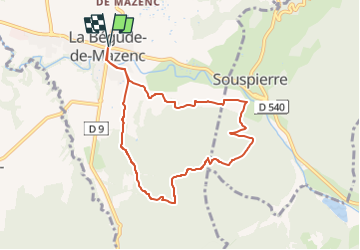
Ruta Senderismo de 8,3 km a descubrir en Auvergne-Rhône-Alpes, Drôme, La Bégude-de-Mazenc. Esta ruta ha sido propuesta por chancha.
Descripción
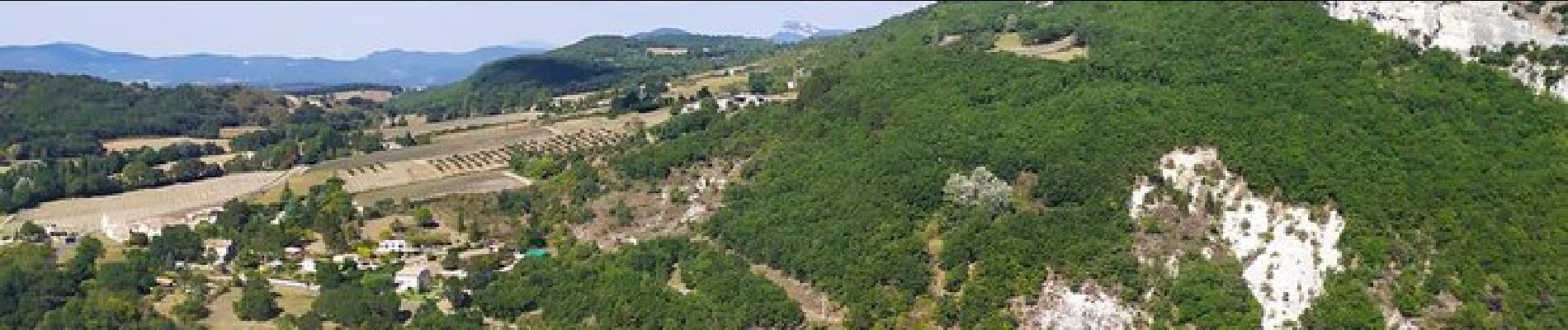
Une boucle variée au-dessus de la Bégude avec de beaux points de vue notamment depuis le belvédère du Serre de Forillon. Si l’ensemble est relativement facile, quelques montées un peu raides demanderont un petit effort au promeneur.
Localización
Comentarios
Excursiones cerca
![Excursión Senderismo Portes-en-Valdaine - 2022-10-01_17h32m32_13243364-1 - Photo](https://media.geolcdn.com/t/375/260/2ea09867-c31b-46c1-94ae-201697a2583c.jpg&format=jpg&maxdim=2)
![Senderismo Senderismo](https://static1.geolcdn.com/sitytour/trail-icons/101.png)
Senderismo
![](/images/other/stat-length.png)
![](https://static1.geolcdn.com/siteimages/upload/files/16400158638029165_repeat_loop_refresh_sync_direction_icon.png)
![Excursión Senderismo Portes-en-Valdaine - Portes-en-Valdaine Serre-de-Mirabel 11km. - Photo](https://media.geolcdn.com/t/375/260/89334076-0011-4fd6-a9cb-db05a56205b4.jpg&format=jpg&maxdim=2)
![Senderismo Senderismo](https://static1.geolcdn.com/sitytour/trail-icons/101.png)
Senderismo
![](/images/other/stat-length.png)
![](https://static1.geolcdn.com/siteimages/upload/files/16400158638029165_repeat_loop_refresh_sync_direction_icon.png)
![Excursión Senderismo Saint-Gervais-sur-Roubion - 2022-10-01_17h25m59_GPX-Moutette-St-Rome-STGervais - Photo](https://media.geolcdn.com/t/375/260/6b20cd10-00dc-411b-8b77-04281c5b5149.jpg&format=jpg&maxdim=2)
![Senderismo Senderismo](https://static1.geolcdn.com/sitytour/trail-icons/101.png)
Senderismo
![](/images/other/stat-length.png)
![](https://static1.geolcdn.com/siteimages/upload/files/16400158638029165_repeat_loop_refresh_sync_direction_icon.png)
![Excursión Senderismo Portes-en-Valdaine - GPX-Rando-Plaine-Portoise-nouvelleversion - Photo](https://media.geolcdn.com/t/375/260/521ae53d-ced6-46fa-9655-4eb3952c25ee.jpg&format=jpg&maxdim=2)
![Senderismo Senderismo](https://static1.geolcdn.com/sitytour/trail-icons/101.png)
Senderismo
![](/images/other/stat-length.png)
![](https://static1.geolcdn.com/siteimages/upload/files/16400158638029165_repeat_loop_refresh_sync_direction_icon.png)
![Excursión Senderismo La Touche - La Touche Crêtes de l'ysard 12km. - Photo](https://media.geolcdn.com/t/375/260/b7717e93-9def-4e5d-8328-3e96528d5925.jpg&format=jpg&maxdim=2)
![Senderismo Senderismo](https://static1.geolcdn.com/sitytour/trail-icons/101.png)
Senderismo
![](/images/other/stat-length.png)
![](https://static1.geolcdn.com/siteimages/upload/files/16400158638029165_repeat_loop_refresh_sync_direction_icon.png)
![Excursión Senderismo La Touche - La Touche : Les Citelles et Serre Pointu 12km - Photo](https://media.geolcdn.com/t/375/260/6be75cc0-9945-4cf3-b3f9-69a08db1d316.jpg&format=jpg&maxdim=2)
![Senderismo Senderismo](https://static1.geolcdn.com/sitytour/trail-icons/101.png)
Senderismo
![](/images/other/stat-length.png)
![](https://static1.geolcdn.com/siteimages/upload/files/16400158638029165_repeat_loop_refresh_sync_direction_icon.png)
![Excursión Senderismo La Touche - La Touche Mastaize 9km - Photo](https://media.geolcdn.com/t/375/260/7617f59d-4270-4583-9eab-9f2081c0076a.jpg&format=jpg&maxdim=2)
![Senderismo Senderismo](https://static1.geolcdn.com/sitytour/trail-icons/101.png)
Senderismo
![](/images/other/stat-length.png)
![](https://static1.geolcdn.com/siteimages/upload/files/16400158638029165_repeat_loop_refresh_sync_direction_icon.png)
![Excursión Senderismo Portes-en-Valdaine - 26 portes en valdaine - Photo](https://media.geolcdn.com/t/375/260/b3cf4f19-20f2-4a60-8f05-2283f4c73166.jpg&format=jpg&maxdim=2)
![Senderismo Senderismo](https://static1.geolcdn.com/sitytour/trail-icons/101.png)
Senderismo
![](/images/other/stat-length.png)
![](https://static1.geolcdn.com/siteimages/upload/files/16400158638029165_repeat_loop_refresh_sync_direction_icon.png)
![Excursión Senderismo La Touche - Citelles hameau et ruisseaux 10km - Photo](https://media.geolcdn.com/t/375/260/ae07cd43-efe5-443c-ada6-328c965bd163.jpg&format=jpg&maxdim=2)
![Senderismo Senderismo](https://static1.geolcdn.com/sitytour/trail-icons/101.png)
Senderismo
![](/images/other/stat-length.png)
![](https://static1.geolcdn.com/siteimages/upload/files/16400158638029165_repeat_loop_refresh_sync_direction_icon.png)